GPR Pavement Layer Thickness Assessment:
Meeting ASTM D4748 at Network Scale
Surface-level inspections are insufficient for modern infrastructure management. While potholes and cracking are visible symptoms of decay, the true state of a road asset is dictated by its subsurface condition.
For State Departments of Transportation (DOTs) and municipal engineers, accurate pavement layer thickness measurement is a critical variable that defines load capacity, guides rehabilitation design, and predicts long-term performance.
Historically, capturing this data required compromise. Engineers had to choose between the accuracy of destructive coring and the limited scalability of traditional impulse ground penetrating radar (GPR). However, as agencies move toward data-driven asset management, the objective has shifted. The goal is no longer just "compliance" with standards; it is the creation of a comprehensive, network-scale Digital Model.
By utilizing vehicle-mounted Step-Frequency Continuous-Wave (SFCW) GPR arrays, engineers can now capture high-resolution subsurface information at traffic speeds. This transforms pavement condition assessment from a localized diagnostic into a strategic asset management tool.
The Engineering Blueprint: Decoding ASTM D4748 Compliance
For any pavement condition assessment GPR survey in the United States, ASTM D4748 (Standard Test Method for Determining the Thickness of Bound Pavement Layers Using Ground Penetrating Radar) provides a defining standard. To understand why modern SFCW arrays are superior for this standard, one must first understand the rigorous technical demands posed by D4748.
The Need for Resolution
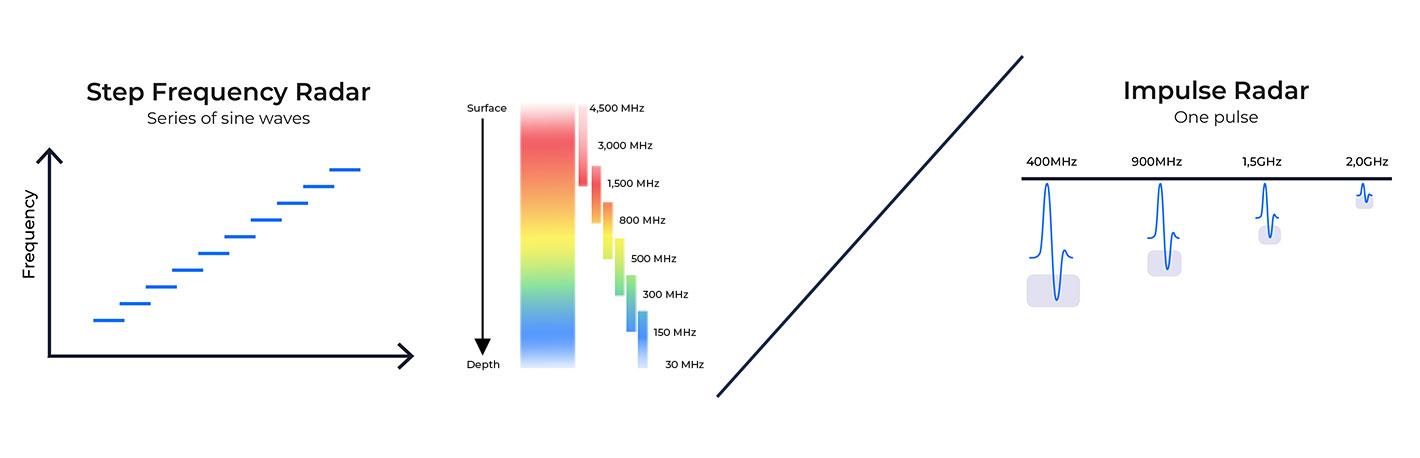
ASTM D4748 provides a specification for determining thickness of bound pavement layers. System specifications provided under the test method imply resolution of one inch (25 mm) is achievable. In reality, traditional impulse GPR systems often struggle with "pulse overlap" when measuring thin overlays. If the GPR pulse is too wide relative to the layer thickness, GPR will show two (or more) thin layers as a single, thicker layer.
Kontur’s SFCW technology solves this by sweeping a continuous range of frequencies from 30 MHz to 4.5 GHz. This provides a massive bandwidth that produces a much narrower synthesized pulse at the high frequency end. The result is the ability to resolve layers less than 1 inch, better than the limit described in the ASTM standard.
Calibration and the "Velocity of Choice"
GPR does not measure depth; it measures time. To convert that time into pavement layer thickness, the GPR system must be calibrated. ASTM D4748 allows for three primary calibration methods:
- Metal Plate Calibration: Comparing the GPR signal at depth to a known surface standard reflection.
- Coring: Taking physical samples to verify layer depths at specific locations.
- Common Midpoint Calculation (CMP): Collecting data from two (or more) antennas separated by known distances.
The strategic error many firms make with GPR processing is assuming a single calibrating dielectric value for excessively long sections of roadway. Pavement density changes. Moisture content varies. Assuming a constant dielectric for too much pavement leads to inaccurate depth reporting.
Sampling Density and Spatial Accuracy
ASTM D4748 emphasizes the need for consistent longitudinal sampling. The standard assumes typical sampling at either the center of the lane or the right wheel path. If only a single path within a lane is captured, transverse variability across the lane remains unknown. Multichannel GPR arrays provide the best fulfillment of the standard. By covering the entire lane width, Kontur’s AIR system provides true 3D data coverage. This ability ensures that the thickness data are not just an assumption based on one line, but a statistically significant representation of the entire pavement structure.
The Physics of Depth: Dielectrics and Wave Velocity
GPR pavement thickness measurement is a “time-of-flight” calculation. The radar unit transmits an electromagnetic wave that travels through the pavement and reflects off the boundaries between layers with different dielectric properties.
The system measures Two-Way Travel Time (TWTT). To convert this time into a depth measurement (d), we must know the propagation velocity (v) of the signal within the pavement material, which is dependent on the material’s Dielectric Constant (ε_r):
d=(vt)/2.
Where:
- v is the velocity of the signal.
- t is the travel time.
The accuracy of this depth is significantly influenced by TWTT accuracy. One factor affecting TWTT is “time drift”. Some (not all) traditional impulse systems are prone to time-drift, where the signal shifts due to temperature changes in the hardware. D4748 even requires system warmup to alleviate that problem. SFCW systems are inherently self-calibrating and exhibit zero time-drift. This means a measurement taken at 8:00 AM is as accurate as one taken at 4:00 PM, a critical factor for large-scale road projects.
Comparing Modalities: Moving from Point-Sampling to Digital Twins
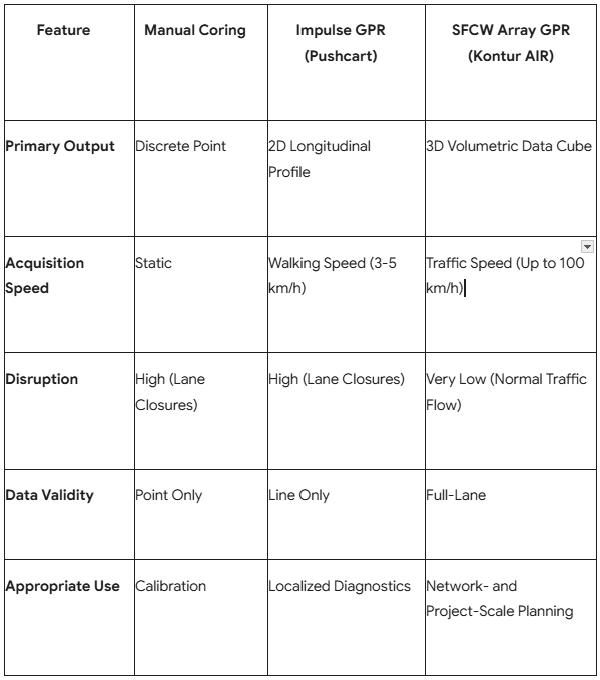
To understand the ROI achievable using SFCW Array GPR for modern pavement assessment, one must contrast the three primary methods of thickness verification:

Why Pushcarts Fail the "Network Test"
Pushcart GPR units are valuable tools for small-scale projects. However, they are a logistical liability for highway management. Using a pushcart for a multi-mile project quickly becomes infeasible:the time and cost for personnel, equipment and closure support exceed the return from the acquired data.
For large-scale pavement assessment, the only logical choice is a vehicle-mounted array capable of acquisition at speed. This allows the agency to collect data without the prohibitive cost and safety risk of personnel working stationary on a live highway.
Read More: Beyond Pushcart GPR
The SFCW Advantage: Turning Raw Data into Asset Intelligence
The value of GPR for pavement maintenance is found not just in the "squiggly lines” of the raw radar data. It is also found in the ability to visualize and export actionable interpretations of that data for a GIS or Pavement Management System (PMS). Kontur’s integrated ecosystem ensures that the superior raw data captured by the SFCW array is leveraged through advanced processing and analysis.
Step 1: High-Speed Capture
The Kontur AIR (https://www.kontur.tech/products/air) sensor is engineered for high-speed, non-contact data acquisition. It utilizes air-launched antenna architecture, meaning it is suspended above the ground rather than dragged along it. This allows for data collection at highway speeds (up to 100 km/h) while maintaining both sub-centimeter vertical and centimeter-level horizontal accuracy.
Step 2: Automated Interface Tracing
ASTM D4748 requires the identification of layer interfaces. In the past, this was done manually by an analyst picking traces across entire GPR sections. That is impossible at the network scale. Kontur’s Examiner Specialist (https://www.kontur.tech/products/examiner-specialist) software utilizes semi-automated "Interface Tracing" algorithms to identify continuous reflections from asphalt and concrete layers, allowing for the rapid generation of thickness profiles across hundreds of kilometers of data in a fraction of the time.
Step 3: The Cloud-Based Digital Twin
The final stage of a modern GPR system for road projects is visualization. Through Kontur Orbit (https://www.kontur.tech/products/kontur-orbit), data is uploaded to a cloud platform. Asset managers can view subsurface details in 3D alongside high-resolution surface imagery. This helps them to see why a road is failing. For example, recognizing that surface cracking is actually caused by localized thinning of the pavement that was missed by random coring; or a recurring pothole is the result of a failing culvert underneath.
The Coring Problem: Why Point Sampling Fails at Network Scale
Traditionally, for pavement problems, DOTs have relied on sampling via cores. However, a standard core represents a statistically insignificant fraction of a lane-mile. If a road section has variable thickness due to settlement or uneven paving, a single core can entirely miss the area of distress.
GPR transforms the role of coring from the primary source of data to a verification tool. For example, instead of taking 50 cores, an engineer can use GPR to scan the entire 50 miles of a project. The GPR data will reveal where pavement is thin or where the base is failing. Coring can then be "targeted" at critical points to calibrate the radar analysis. This "GPR-first" approach can reduce the total number of cores needed by up to 90% while increasing the overall confidence in the dataset to near 100%.
Case Study: 500 Kilometers of Assessment in Alberta
The power of this approach was recently demonstrated in a landmark project with the global engineering firm Tetra Tech. Utilizing the Kontur AIR 3D GPR system, the team assessed 500 lane-kilometers of roadway in Alberta, Canada.
The objective was to analyze pavement structure, identify variable layer thicknesses, and detect subsurface anomalies such as delamination. The system operated at traffic speeds, collecting approximately 100 km of data per day. The result was a comprehensive data acquisition program completed in just five days without a single lane closure. For the client, the result was a shift from “treat what looks worst at the surface” to targeted interventions based on subsurface reality; reducing uncertainty in both budgeting and design.
When GPR is the Strategic Choice for Pavement Assessment (And Its Limitations)
While SFCW GPR is the most powerful tool available for pavement layer thickness measurement, an analyst must also understand its limitations to ensure project success.
Material Conductivity: GPR performs exceptionally well in dry, bound layers like asphalt and concrete. However, where conductive minerals such as clay are present in the foundation soil or the aggregate base, signal attenuation increases and successful delineation of interfaces is less certain.
Thin Overlay Resolution: While Kontur’s 4.5 GHz bandwidth is industry-leading, resolving layers thinner than 2 cm remains a technical challenge for all GPR systems.
The Need for Calibration: No GPR system is "plug and play" for absolute depth. As described in ASTM D4748, some number of physical cores or common midpoint measurements are always required to anchor the data to real-world measurements.
Conclusion
The transition from small-scale repair projects to network-scale pavement maintenance represents a fundamental shift in the use of GPR for infrastructure management. ASTM D4748-compliant GPR surveys are no longer just a "check-the-box" requirement for local projects; they are a baseline for modern, data-driven pavement management systems.
By eliminating the limited number of channels and frequency constraints of legacy systems, Step-Frequency Continuous-Wave (SFCW) arrays provide superior performance to achieve the data density required for high-confidence structural modeling.
When an agency can capture high-resolution layer thickness at 100 km per day, the economics of road assessment change. Data gaps are resolved, project risks are reduced. Most importantly, maintenance budgets can now be allocated and treatments scheduled based on predicted performance thresholds rather than responses to visual roadway stress where damage has already occurred.
Good data on pavement condition is a strategic imperative for safe and thriving communities. By measuring the subsurface at traffic speeds, Kontur enables asset managers to move from reactive repairs to scheduled preventative maintenance. This evolution ensures that every dollar spent on the road network is backed by the most accurate condition intelligence available today.
Aligning Your Network with ASTM D4748 Standards
Applying the ASTM D4748 standard to a highway network is a complex logistical and technical task. It requires more than just a radar unit; it requires a workflow designed for high-speed accuracy and data management.
If your agency is evaluating a network-scale pavement assessment initiative, our team can provide a consultative review of your current approach and share proven strategies used by leading transportation agencies and engineering organizations. Rather than prescribing a one-size-fits-all solution, we work within your existing structure to identify the most effective path forward.
During a Technical Scoping Session, we can help you:
- Review Existing Workflows: Evaluate how high-density subsurface data can complement your current PMS, GIS, and asset management processes.
- Learn from Proven Deployments: Explore how major transportation agencies, engineering consultants, and infrastructure owners have successfully implemented network-scale GPR programs to improve planning confidence and reduce uncertainty.
- Optimize Survey Strategy: Determine the most appropriate sensor configuration, acquisition methodology, and calibration approach for your pavement network and engineering objectives.
- Build a Business Case: Quantify potential reductions in coring requirements, traffic control costs, field time, and project risk while improving network-wide visibility.
Whether your goal is network-level asset management, rehabilitation planning, or project-specific design support, our team can help you structure an assessment program that delivers actionable engineering intelligence while fitting seamlessly into your existing operations.
Ready to evaluate what a network-scale assessment program could look like for your agency? Schedule a Technical Scoping Session with our team.
Frequently Asked Questions (FAQ)
When calibrated against cores per ASTM D4748, GPR is accurate to within ±10% of the actual thickness. Kontur systems, with their excellent bandwidth and ultra-high frequency top end, can achieve better than 5% accuracy for pavement layers. In many cases, the high spatial density of GPR data provides better statistical correlation to true thickness than a sparse collection of physical cores.
Does ASTM D4748 require a specific type of GPR?
No, but it requires that the system has sufficient performance (signal-to-noise, signal stability, high-end frequency) to resolve pavement layer interfaces. For network and project-level surveys, SFCW systems are the best (and sometimes, the only viable) option for meeting these performance requirements while operating at highway speeds.
Can GPR distinguish between multiple asphalt overlays?
Yes. Because Kontur’s SFCW technology sweeps a wide frequency range (up to 4.5 GHz), it provides industry-leading resolution of thin pavement layers and can detect contrasts between different ages or types of asphalt overlays, provided there is a measurable difference in dielectric properties between the layers.
Does the system require a lane closure for highway assessments?
No. When using air-launched sensors (Kontur AIR) and vehicle-mounted arrays, data can be collected at normal traffic speeds. This eliminates the need for lane closures, significantly reducing project costs and increasing safety for survey personnel.