Step-Frequency Radar vs. Impulse GPR:
– The Modern Standard for Network-Scale Infrastructure Assessment
The efficient management of critical infrastructure requires subsurface data that is not only high-resolution but also scalable, quantifiable, and easily integrated into long-term asset management platforms. Traditional Ground Penetrating Radar (GPR) systems, constrained by their foundational operating principles, often present inherent compromises in image quality and operational speed, failing to meet the complex demands of modern high-speed assessment and 3D modeling.
In this article, we compare the two primary GPR technologies—impulse and step-frequency continuous-waveform (SFCW)—and show how their physical characteristics translate directly into:
- Throughput and disruption: How fast you can reasonably collect data over highways and bridges, and what it costs in lane closures and traffic control.
- Data quality and flexibility: Whether you get a narrow 2D slice that’s hard to reinterpret, or a wideband 3D data cube you can reprocess without re-surveying.
- Risk and ROI at program scale: How each technology affects change orders, follow-up surveys, and long-term decision confidence.
In what follows, we’ll move to the field implications (throughput, coverage, re-surveys) and then to real project examples.
Defining the GPR Technologies: Time-Domain Constraints vs. Frequency-Domain Flexibility
The core difference between GPR systems lies in how the radar signal is transmitted, a factor that dictates the achievable resolution, penetration depth, and post-acquisition data flexibility.
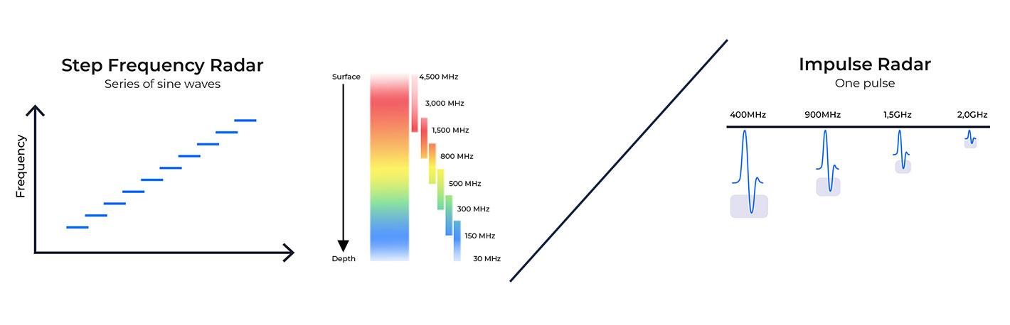
Impulse Radar: The Fixed-Pulse Constraint
Impulse GPR systems operate by transmitting a fixed, short-duration electromagnetic pulse into the ground, capturing the reflection data directly in the time domain.
- The Inherent Trade-Off: The impulse mechanism imposes a fundamental trade-off. In time-domain systems, antenna central frequency determines the balance between penetration depth and vertical resolution: lower central frequencies penetrate deeper but provide coarser resolution, while higher central frequencies improve resolution but attenuate more rapidly. Because each antenna operates at a fixed central frequency, both cannot be optimized simultaneously.
- Operational Limitation: To cover a wide range of targets and depths with adequate quality, impulse systems often necessitate complex, multi-antenna setups or repeated surveys using antennas with different frequencies (e.g., 200 MHz for depth, 800 MHz for shallow resolution).
Step-Frequency Radar (SFCW): Continuous Coverage and Data Superiority
Step-Frequency GPR technology fundamentally changes the acquisition process. Instead of a fixed pulse, the system transmits a continuous series of sine waves with a linearly increasing frequency.
- The Ultra-Wideband Advantage: Data is collected by measuring the phase and amplitude at each frequency. The frequency domain data is then converted via a Fourier transform into a time-domain profile. Critically, a single Kontūr antenna provides frequency coverage from 30 MHz up to 4.5 GHz. This ultra-wideband coverage from one sensor overcomes the impulse compromise, providing high resolution across a broad depth range in a single survey.
- System Efficiency: The SFCW technology is self-calibrating and exhibits no time-drift, removing the typical requirement for field warm-up time. Furthermore, its low peak-power signal reduces the probability of interference with other radio systems.
The Core Differentiator: ROI of Speed and Data Flexibility
The technical advantages of the SFCW array systems translate directly into quantifiable efficiency gains and project risk mitigation, serving as the core business justification for adoption.
Maximizing Throughput: High-Speed Acquisition at Traffic Pace
In infrastructure management, speed of acquisition is directly proportional to ROI due to reduced traffic disruption and operational time.
- The Speed Metric: Vehicle-mounted SFCW arrays, such as the air-launched Kontūr AIR sensor, are specifically optimized for high-speed, non-contact data acquisition. These systems are engineered to collect comprehensive data at traffic speeds.
- Proven Efficiency: In a real-world pavement assessment of 500 lane kilometers of road, global engineering firm Tetra Tech utilized the Kontūr AIR system to efficiently collect on the order of 100 lane kilometers of data per day. This high throughput significantly reduced the need for slow, costly confirmatory pavement cores.
Data Flexibility: Eliminating Costly Re-Surveys
A unique and often underappreciated value of SFCW is the flexibility of its raw data.
- Frequency-Domain Value: Since the raw data is stored in the frequency domain, it can be easily and efficiently reprocessed post-acquisition using the Examiner Specialist software.
- Risk Mitigation: This capability allows engineers to apply different spectral re-weighting to the existing dataset to optimize for features of interest—such as a specific deeper utility or near-surface concrete feature—without needing to return to the site and physically re-survey. This capacity to respond to new queries after the fact eliminates significant project delays and costs.
Advanced Analysis: Capabilities Unique to the SFCW Ecosystem
Kontūr’s integrated ecosystem ensures that the superior raw data captured by the SFCW array is leveraged through advanced, proprietary processing, exceeding the capabilities of conventional single-profile interpretation.
Enhancing Image Clarity
- Function: The raw frequency-domain data is perfectly suited for advanced spatial-domain processing. This process, executed by the Kontūr Examiner Specialist software, enhances image focusing and removes signal clutter.
- Output: The result is a highly focused, georeferenced 3D data cube, significantly improving the target localization accuracy essential for high-density visualization.
Bridge Deck and Pavement Integrity Analysis
- Advanced Detection: The system’s optimal source signature and wideband spectrum enable advanced signal characterization and enhanced subsurface feature differentiation.
- Application: This advanced analysis moves "Beyond ASTM D-6087" to study phenomena like concrete delamination and moisture content, providing technical superiority in assessing the overall structural health of bridge decks and pavements.
Industrial Application: The Array Advantage in Complex Environments
The true test of GPR technology is its performance in large, high-risk industrial scenarios.
Mapping the "Unmappable": Complex Urban Tomography
- The High-Value Niche: In dense urban cores with historically undocumented infrastructure, a standard 2D profile is insufficient. The dense, multi-channel 3D subsurface data from wide-array SFCW systems provides a crucial layer of verification, often referred to as "radar tomography".
- Case Example: For a major electrical grid enhancement project in Boston, DGT Associates utilized a 2.1-meter Kontūr wide-array GPR system. The system was key to identifying undocumented infrastructure, including buried vaults and abandoned tunnels. This high level of detail is critical for mitigating the risk of project delays, claims, and escalating costs in complex infrastructure renewals.
Not All SFCW is Created Equal: Array Systems vs. Single Antenna Systems
The market often conflates the technology with the device, yet the industrial-scale performance of wide-array systems is fundamentally different from single antenna systems.
While many single antenna systems advertise “step-frequency” operation, their narrow aperture and low channel count keep them in the 2D, local-diagnostic world. Wide-array systems are designed for network-scale mapping, not spot checks.
- The Array Advantage: Kontūr’s multi-channel sensor arrays are designed for speed and coverage, moving users from 2D rebar hunting to true 3D infrastructure mapping. This array design enables fast and efficient data acquisition over large areas, a capability that a handheld device cannot replicate when the project mandate is to map an entire highway network at highway speeds.
Conclusion: The Strategic Imperative for Modern GPR Adoption
The evidence demonstrates that Impulse GPR's inherent compromises in the time domain, which necessitate trade-offs between resolution and depth, can be limiting for the speed and data quality required by modern, large-scale infrastructure asset management.
The integrated SFCW ecosystem—combining patented sensor arrays (AIR, GROUND, DEEP), the Examiner™ software suite, and the cloud-based visualization platform—is a data-driven path to de-risk multi-billion dollar projects. It provides high-resolution, actionable 3D intelligence at traffic speed, enabling proactive maintenance and management of critical assets.