Beyond the Pushcart GPR:
– Why Industrial-Scale Array GPR is Critical for Network-Level Highway Asset Management.
Handheld and cart-based GPR are excellent tools for local diagnostics: clearing a borehole, checking rebar in a slab, or resolving a small anomaly. But they were never designed to answer the questions that state DOTs and highway agencies now face: Which corridors should we treat first? How is our pavement structure really performing across hundreds of lane-kilometres? Where are we taking unnecessary risk?
Network-level asset management requires subsurface data that is continuous, repeatable, and collected at traffic speed—not a patchwork of 2D line scans.
In this article, we contrast pushcart GPRs with industrial-scale, vehicle-mounted step-frequency arrays and show how the underlying hardware differences drive outcomes in:
- Operational economics: How lane closures, night work, and safety risk change when you move from walking speed to traffic-speed acquisition.
- Data quality and coverage: 2D line profiles vs. true 3D data cubes that time-slice across the full lane width.
- Pavement intelligence and testing strategy: How dielectric profiling and network-wide coverage enable targeted coring and better use of maintenance budgets.
> Ready to evaluate the ROI of high-speed subsurface mapping for your network?
> **Start by reviewing a recent 500 km highway project with our engineers.**
Introduction: The Network-Level Challenge
For decades, Ground Penetrating Radar (GPR) in pavement applications has been synonymous with walking-speed, pushcart-based systems — valuable diagnostic tools for locating rebar in a single slab or clearing a specific borehole location. However, a fundamental mismatch exists between the capabilities of these pushcart units and the scale of modern highway infrastructure. You would not want to map a 500-kilometer highway network with a metal detector, and you cannot digitize network-level assets with a handheld GPR unit.
State Departments of Transportation (DOTs) and asset managers are currently transitioning from reactive maintenance models to predictive, data-driven asset management. This shift requires a density of data and a speed of acquisition that manual scanning methods physically cannot provide. While pushcart units act as excellent "stethoscopes" for localized diagnostics, effective highway management requires an "MRI" of the entire infrastructure body. This level of insight is only achievable through industrial-scale, vehicle-mounted Step-Frequency Continuous-Wave (SFCW) arrays.
The Operational Reality: Traffic Speeds vs. Lane Closures
The primary operational differentiator between pushcart GPRs and vehicle-mounted arrays is the cost of disruption. Pushcart GPR units typically operate at a walking pace (approx. 3-5 km/h) and require static traffic management. For high-volume highways, this necessitates expensive lane closures, night work, and significant safety risks for personnel exposed to live traffic.
In contrast, industrial array systems, such as the Kontūr AIR, are engineered for high-speed deployment. By utilizing air-launched antenna architectures, these systems are engineered to collect high-resolution 3D data at traffic speeds.
This speed differential fundamentally changes the economics of data collection.
- Pushcart Output: A typical crew might cover a fraction of a kilometer per shift, limited by battery life, operator fatigue, and traffic control logistics.
- Array Output: In typical highway deployments, a vehicle-mounted array can document on the order of tens of lane kilometers per day; in one large-scale project, approximately 100 lane kilometers per day were collected.
This efficiency allows asset managers to conduct network-wide assessments without disrupting the public or incurring the prohibitive costs of traffic control services.
Technical Divergence: 2D Profiles vs. The 3D Data Cube
The distinction between handhelds and industrial arrays is not merely operational; it is strictly hardware-defined. Standard handheld units typically utilize a single channel or a small, narrow array, producing 2D line scans. These scans rely heavily on the operator's interpretation in the field and often lack the lateral resolution to resolve complex features spanning the pavement width.
The Multi-Channel Advantage
Industrial systems like the Kontūr AIR 3036 utilize up to 36 individual channels with a customizable scan width of up to 2.7 meters. This high channel density produces a true 3D data cube rather than isolated 2D profiles.
This volumetric data allows for "time-slicing"—the ability to view subsurface data at specific depth horizons horizontally. For highway engineers, this means visualizing the continuity of pavement layers or the extent of moisture ingress across the entire lane width, rather than extrapolating from a single longitudinal line.
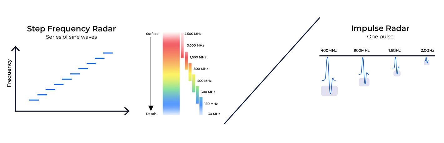
SFCW: The "One-Pass" Spectral Efficiency
Traditional impulse GPR systems often force a compromise between depth and resolution. An operator must choose a high-frequency antenna (e.g., 1.5 GHz) for shallow rebar detection or a low-frequency antenna (e.g., 400 MHz) for deep utility mapping.
Step-Frequency Continuous-Waveform (SFCW) technology eliminates this trade-off. The system sweeps a continuous frequency range from 30 MHz up to 4,500 MHz in every scan. This ultra-wideband coverage captures the full frequency response of the subsurface in a single pass. Consequently, a single survey vehicle can simultaneously map deep utility crossings (requiring low frequencies) and near-surface pavement delamination (requiring high frequencies), doubling the data value per operational hour.
Pavement Intelligence: Beyond Rebar Detection
For highway asset management, the goal is rarely simple object detection; it is structural health monitoring. Industrial arrays equipped with SFCW technology provide quantitative data on pavement quality that goes beyond what visual inspection or sparse manual coring can provide.
Dielectric Profiling for Density
The Kontūr system continuously measures dielectric values across the pavement surface. Because the dielectric constant of asphalt is directly correlated to its density and air void content, this data allows engineers to assess Hot Mix Asphalt (HMA) quality non-destructively.
Reducing Destructive Testing
Traditionally, pavement assessment relies on extracting physical cores—a destructive, slow, and spatially limited method. By deploying an array system, engineers can transition to a "targeted coring" methodology. The GPR data provides 100% coverage of the road network, highlighting specific anomalies or areas of variable density. Coring can then be limited to these verification points rather than random sampling, significantly reducing project costs and preserving pavement integrity.
Case in Point: 500 Kilometers of Assessment in Alberta
The theoretical advantages of array GPR have been proven in large-scale commercial deployment. In a landmark project with global engineering firm Tetra Tech, the Kontūr AIR 3D GPR system was utilized to assess approximately 500 lane kilometers of roadway in Alberta, Canada.
- Objective: Analyze pavement structure, identify variable layer thicknesses, and detect subsurface anomalies such as delamination.
- Execution: The system collected data at traffic speeds, averaging ~100 km of acquisition per day.
- Outcome: The project delivered a comprehensive structural analysis without a single lane closure. The data allowed the client to pinpoint specific areas of distress that required maintenance, moving budget allocation from "guesswork based on surface cracks" to "precision repair based on subsurface reality."
For the client, the result was a shift from “treat what looks worst at the surface” to targeted interventions based on subsurface structure and layer continuity—reducing uncertainty in both budgeting and design.
Conclusion: The Right Tool for the Asset
Handheld GPR units will always have a place in the toolkit for vertical structures and tight, inaccessible areas. However, they are not the correct instrument for linear infrastructure management.
As State DOTs and municipalities face aging infrastructure and tightening budgets, the efficiency of data collection becomes paramount. Industrial-scale SFCW arrays provide a practical path to creating a "Digital Twin" of the highway network—delivering the high-speed, high-resolution 3D intelligence necessary to de-risk maintenance strategies and ensure safe, thriving communities.